
Magellan CrossoverGPS Review
Magellan CrossoverGPS
I am a map guy, always have been. Some of the best times in my life have been sitting across the desk from my auto club’s trip planner watching them with their little green highlighter pen preparing strip maps for the family vacation to the beach or some other destination. I will huddle over my maps pre-trip, hoping to happen across some as yet undiscovered attraction or landmark. I have also been known to pull the maps out from trips past to try to recapture the magic of some long ago road trip.
My passion for maps, however, has finally succumbed to another passion, the one I hold for electronic gadgets. Like most of us, my first experience with GPS-based navigational systems came while renting a car with one of the units installed and I immediately fell in love. I was enthralled by the thought of being able to land in a heretofore unvisited locale and immediately be able to get where I wanted to go without consulting the slack-jawed yokels at the counter. And while I will never lose my love of the paper variety, the electronic version of the road atlas certainly does offer some enhancements (insert obligatory map folding joke here).
Magellan offers a variety of GPS products from their Maestro‘ and RoadMate‘ models clearly intended for use in motor vehicles to their eXplorist‘ model intended primarily for outdoor use. The CrossoverGPS‘ is touted as “the world's first fully-featured, crossover pocket size GPS. It has all the standard features of the advanced Magellan auto navigation GPS products, plus the ability to go from the open road to the great outdoors with one GPS”, and it fills an interesting little niche in the marketplace. I must say that I am interested in meeting the person in whose pockets this item will fit because at 9.2 ounces I tended to list to the side holding the GPS, throwing off my ability to walk in a straight line.
Features & Operation
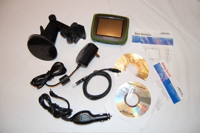
Upon opening the package I found all the items expected to accompany a GPS navigator: the unit itself, a suction cup mounting bracket for mounting it to your windshield, both an AC adapter for charging the battery at home and a car charger for charging on the go, two CD-ROMs containing the instruction manuals and an application for creating customized lists of Points of Interest (POIs), a USB cable, warranty cards and various other printed material. One of the handiest things I pulled out of the box was the Quick Reference guide, in fourteen panels of instructional goodness that laid out the basic functions of the unit.
The unit itself looks just like the Magellan RoadMate units, but with a removable rubberized sleeve that surrounds the unit to protect it when tossed in a bag or is dropped. The I/O ports are also protected from the elements by rubber gaskets designed to keep water, dirt and grime out of them. The marketing materials indicate that the unit is waterproof to IPX-4 levels (which basically means that it is waterproofed from splashing water from all sides), but I could find no mention of the specifications in the instruction manual.
 The unit has three modes of operation: auto, marine and outdoor navigation and comes preloaded to do auto navigation right out of the box. It also has 90-meter topographic maps pre-loaded for outdoor navigation. Higher resolution topographic maps and marine maps are available for purchase from the Magellan website. Since I live in the US, my review unit came with the maps for my continent, but according the Magellan website, units can be preloaded with maps for Europe as well.
To use the unit’s auto navigation function, it needs merely to be told where to go. There are a several ways to do that. Enter a street address manually using Magellan’s QuickSpell‘ system that compares what is being typed against a database of known city and street names and addresses to aid in the process of inputting addresses. You can start with either a city name or zip code (very nice if you know the zip code of where you are headed) and then put in the street name and address.
Another option for choosing a destination is searching the unit’s database of Points of Interest (POIs). It can be searched category (i.e. restaurants, gas stations, hotels) or by name. The database seemed to be outdated, with a number of restaurants listed near my house that have not been there for almost a year and a half. Also, the unit would not locate the Ben & Jerry’s in town or the Wendy’s I was standing in front of for dinner the other night. Apparently the POI database is updated at the same time the maps are updated, every 12-18 months. In fact, according to Magellan’s website, a map update is scheduled for December 2007 for the CrossoverGPS. Magellan’s map provider is NAVTEQ.
While researching this issue on the company’s website, I discovered that Magellan has released a firmware update for this unit. The website requires you to be a registered user with a product serial number to download the update, so after completing that process it was as easy as clicking a link to get the software onto my PC. After that, the instructions on the website led me through the process installing the drivers necessary for connecting to the unit (aren’t PCs great) and then actually installing the upgrade to my unit. If the process of downloading and installing updates and purchased maps is as easy as the firmware update was, the average user should be fine. Keep in mind though a Windows-compatible PC is required to install the updates.
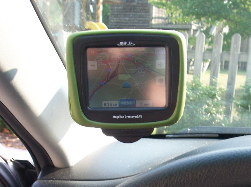 The firmware update significantly updated the look and feel of the user interface, cleaning up what is presented to the user in various modes of auto navigation. And frankly, the changes were very welcome. It’s not that it was a bad interface (prior to the update), but placement of buttons, particularly when viewing the map, just made a lot more sense after the update. Once the address is entered, simply touch the route button and choose from one of four options: shortest time, shortest distance, least use of freeways or most use of freeways. These options are used primarily for choosing between the scenic route and the quickest route. Once that choice is made, you are on your way. Once the destination information is input, then the unit calculates the route and kicks into map mode. Initially, I was kind of thrown off by the 3D nature of the interface, being used the 2D map mode found on their product for the rental car industry, but I soon came to see the benefits of using the 3D version of the map. Another difference from the rental units is that the CrossoverGPS spoke the street names I needed to turn on, which is infinitely easier than just “Turn Right in 100 feet”.
The thing that makes the CrossoverGPS unique within the Magellan family of products, is the ability to have auto navigation, marine and topographical maps co-existing on the same unit.
The unit I received for this review did not have any of the marine maps installed (which I am glad about, as I did not want to go out and buy a boat to test them - that would have been a hard sell around the house), but it did have 90-meter topographical maps installed.
To put the unit though it’s paces in outdoor navigation mode, I decided to try something called geocaching (for more information visit www.geocaching.com). This website contains a huge database of sites where people have hidden a variety of items, noted the coordinates of where they hide them and invite people to find them. My son and I chose a couple to try out and set out with the unit in hand to try to find them. We found one and gave up on the other after attracting rather odd stares from the soccer players around the second location.
Inputting the waypoint coordinates was fairly straightforward and staying on route was very easy using the unit’s Nav Road View, which gives you a virtual road to follow and constantly updates the user on how much farther it is to the designated waypoint. An observation I made when using the unit outside was that it was a bit difficult to read in direct sunlight, while in my car the display was incredibly easy to read and bright enough,. There were times I had to use my hat to shield the screen from the sun to be able to read the display.
The unit will also allow you to designate a base camp, wander away from it and keep track of the path you take. Then simply touch the Goto Basecamp button and the unit will guide you right back to the waypoint you designated as your basecamp. I can see where this unit with it’s outdoor navigation features would be great to have on family hikes and camping trips, though hardcore backpackers and campers might appreciate other smaller and lighter GPS products available in the marketplace.
Two features touted by Magellan found on the unit are the Photo Viewer and the Digital Music player, and indeed the unit does allow you to both view photos and play digital music, though I cannot tell you why you would want to do that. At 3.5”, the unit’s color display is only slightly larger than LCD displays found on the back of most cameras and the tiny enclosed speaker reminded me of the Realistic FlavoRadio I used to listen to Chicago Blackhawk hockey games in the early 70’s. The use this feature, you will need to install the Magellan CrossoverGPS Tools onto a Windows-compatible PC from the included CD-ROM and then connect the unit with the included USB cable. Music will need to be in MP3 or WMA formats while images can be in variety of formats. The music and images need to be stored on an SD card that you provide.
Conclusion
The CrossoverGPS is a great piece of gear. It has good functionality and is competitively priced when compared to what the auto manufacturers are charging to have one installed in a vehicle. I also like to have the ability to move it from vehicle to vehicle. Having the triple functionality of vehicle, marine and outdoor navigation all in one unit makes the unit very attractive. I was very disappointed in the outdated POI database and that severely limited the utility of the unit. I would love to try the unit again after the scheduled map update in December 2007. Battery life on the unit seemed to be as advertised, but I did not have it on continuously for any length of time. I suspect that on a long road trip, it would be advisable to keep the unit plugged in using the car adapter.
Specs:
- MSRP: $399.99
- Size: 3.4" H x 4.3" W x 1.1" D
- Weight: 8.5 oz. with Sport Guard™ 9.4 oz.
- Display: 3.5" color touch screen display, 2.11" x 2.81" (53.6mm x 71.5mm)
- Memory: 1.5GB of NAND pre-loaded with maps of the 50 United States, Canada, Puerto Rico and topographic maps of the 48 contiguous states
- Power Source: Li-Ion rechargeable 1900mA, 12 V AC or 12 vehicle adapter (sold separately)
- Battery Life: Over 8 hours continuous use
Just about right
Is It Easy to Use?
If you have a pulse
Category
hybrid
Price
about right
For more information:
960 Overland Court
San Dimas, CA 91773
909 394 5000
About Gear Corner
Welcome to the Gear Corner, where we give you a quick but comprehensive look at consumer electronics from several different categories. All products in the Gear Corner have been individually evaluated through hands-on testing by our reviewers in order to give you a quick but detailed overview that we hope will help you in your purchasing decisions.